Aerial Mapping & 3D Modeling

See your site
from above — in detail.

Precise orthomosaic maps and oblique 3D models built from hundreds of aerial photos. Fast to capture. Easy to use. Hard to argue with.

What We Deliver

Two powerful ways to see your site

Every project is different, but the goal is the same: give you an accurate, current, detailed picture of your site that you can actually use.

193 photos
Orthomosaic Map

A complete aerial map of your site

Hundreds of overlapping photos captured in a precise grid pattern, then stitched into a single high-resolution top-down image. The result is an accurate, detailed aerial view of your entire site — current as of the day we flew.

  • Site documentation and progress records
  • Planning and layout reference
  • Before-and-after comparisons
  • Stakeholder and client updates
318 photos
3D Oblique Model

Walk through your site in 3D

Photos captured from multiple angles around the site are processed into a fully navigable 3D model. See every roofline, grade change, and structure from any direction — the way no single photo ever could.

  • As-built and existing conditions documentation
  • Structural and site review
  • Presentations to clients or stakeholders
  • Visualizing changes over time
The Method

Systematic coverage. No gaps, no guesswork.

Before every flight, we pre-plan every waypoint using GPS-guided software. The drone executes the exact plan — covering the entire site with consistent altitude, speed, and photo overlap.
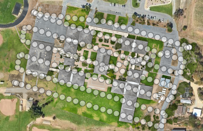
Nadir grid flight pattern for orthomosaic mapping
Nadir Grid Pattern — Orthomosaic

The drone flies a tight grid of parallel passes directly overhead. Every photo overlaps the next by 75% or more — all 193 of them — giving the processing software everything it needs to stitch a seamless, accurate map.
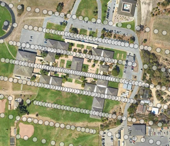
Orbital oblique flight pattern for 3D modeling
Orbital Oblique Pattern — 3D Model

The drone orbits the site at multiple angles and altitudes, capturing the sides of structures as well as the top. 318 photos from every angle is what allows the software to reconstruct a full 3D model.

Who It's For

Any project that needs accurate aerial documentation

If you need to know exactly what your site looks like — right now, from above, in detail — this is for you.

🏗️

Construction

Document site conditions before breaking ground. Track progress week by week. Show clients exactly where things stand — without putting anyone on a ladder.

🏘️

Property & Development

Capture existing site conditions for planning. Generate aerial imagery for listings, proposals, and presentations that make an impression.

🌾

Agriculture & Land

Map fields, document land conditions, and create visual records of acreage that are faster and more complete than any ground-based approach.

📋

Documentation & Records

Create a high-resolution visual record of a site at a specific point in time — for insurance, legal, environmental, or archival purposes.

What You Get

Delivered in the format your team needs

Tell us how you work and we'll deliver the data in a format you can actually use — whether that's a file your software opens, a video you can share in a meeting, or a link you can send to anyone.

High-res orthomosaic image Navigable 3D model MP4 video flythrough GeoTIFF KMZ / Google Earth Point cloud Shareable web link Whatever your workflow needs
Get a Quote

Tell us about your project.

Fill out the form or give us a call. We'll follow up quickly with questions, a timeline, and a price — no commitment required.

415-640-4059

Leave a voicemail if no answer — we'll call back as soon as possible.

We respond promptly — usually within a few hours during business hours.